Exploring the roadblocks and technical hurdles in labeling LiDAR point clouds for real-world AI applications
Light Detection and Ranging (LiDAR) has fundamentally reshaped how machines sense and understand their surroundings. By sending out laser pulses and measuring their return time, LiDAR generates dense 3D maps—known as point clouds—that capture fine geometric detail. These datasets are now core to self-driving technology, robotics, aerial mapping, and advanced object recognition.
As AI systems increasingly depend on spatial awareness, the accuracy of training data is crucial. Properly annotated LiDAR data isn’t just useful—it’s a necessity. Models for detection, scene interpretation, and navigation live or die by annotation quality. But unlike 2D imagery, labeling millions of irregular, sparse points per frame is anything but simple.
This article highlights the major challenges in LiDAR annotation and the innovative approaches being developed to tackle them.
Complexity of LiDAR Data
Unlike images or video, LiDAR outputs point clouds: millions of data points within a 3D coordinate system. Each point conveys spatial and geometric context, but working with them presents unique difficulties.
Key challenges include:
- High Resolution: Modern scanners create extremely detailed clouds, but the sheer volume complicates annotation.
- Sparsity vs. Density: Distant regions are sparse, while urban scenes may be overcrowded with points, making segmentation tricky.
- Dynamic Environments: Vehicles, people, and objects constantly move, requiring flexible annotation strategies.
- Elevation & Occlusion: Objects overlap and appear at varying heights, demanding context-aware labeling.
Annotation Process Challenges
Annotating LiDAR data is more than drawing boxes—it requires understanding depth, scale, and orientation. This adds time, complexity, and dependence on expert annotators.
Labeling Point Clouds
- Context Awareness: Points must be grouped by geometry and scene context.
- Obstruction: Partial visibility complicates accurate labeling.
- Sparse Regions: Low-density areas make object boundaries hard to define.
- Crowded Scenes: Distinguishing tightly packed objects is labor-intensive.
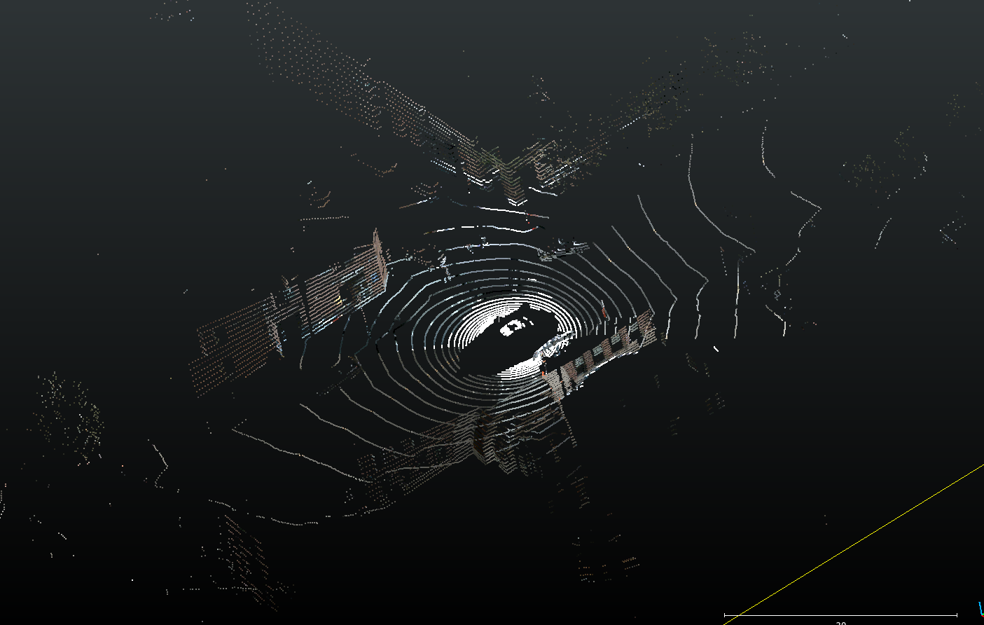
Sparse LiDAR points hinder accurate object boundary detection
Cuboid Annotation
3D bounding boxes define objects in space but are far harder to create than 2D boxes.
Challenges include:
- 3D Complexity: Defining orientation across axes is time-consuming.
- Irregular Shapes: Natural or complex objects don’t fit neatly into cuboids.
- Partial Occlusion: Estimating hidden dimensions is difficult.
- Congested Environments: Maintaining accuracy without overlaps is challenging.
Segmentation Labeling
Semantic segmentation assigns a label to every single point. This requires near pixel-level precision in 3D.
Complications arise from:
- Noise: Sensor reflections and environmental effects distort data.
- Category Ambiguity: Similar objects can be difficult to distinguish without color or texture.
- Ground Separation: Differentiating objects from the ground surface adds extra work.
Labeling Lidar point clouds for segmentation can be a time taking and error prone task.
Noise, Outliers, and Variability
LiDAR is highly sensitive to conditions. Weather, lighting, and reflective surfaces introduce errors, making annotation less reliable.
Sources of noise: rain, fog, reflective materials, and motion blur.
Mitigations: filtering (SOR, voxel grids) can help, but noise remains a barrier to quality annotation.
Other Environmental Factors
Annotation quality is impacted by unpredictable real-world scenarios:
- Weather & Lighting: Reduce clarity despite LiDAR’s independence from ambient light.
- Dynamic Objects: Moving elements must be consistently labeled across frames.
- Terrain Variations: Slopes and uneven ground complicate 3D placement.
Multi-Sensor Integration
Sensor fusion combines LiDAR with cameras, radar, or IMUs to enhance perception.
Benefits:
- Cameras provide texture, radar offers robustness in poor weather.
Challenges: - Synchronization, calibration, and ensuring consistent labels across modalities.
Requirements for High-Quality Annotation
Strong AI models depend on annotation that is:
- Accurate at scale
- Performed by trained annotators
- Validated with multiple QA steps
- Supported by advanced tools like AI-assisted pre-labeling and smart filtering
Annotation Tools to the Rescue
Modern platforms like Mindkosh address these hurdles with:
- AI Assistance: Auto-prelabeling to cut manual effort.
- 3D Visualization: Multi-angle navigation for complex scenes.
- Sensor Fusion: Overlaying camera context on LiDAR for clarity.
- Collaborative Workflows: Issue tracking and QA pipelines for consistency.
- Efficiency Features: Interpolation, predefined cuboid sizing, and dimension locking.
Experienced Teams Matter
While tools improve efficiency, skilled annotators remain essential. Teams with 3D labeling experience ensure higher accuracy, especially in multi-sensor setups.
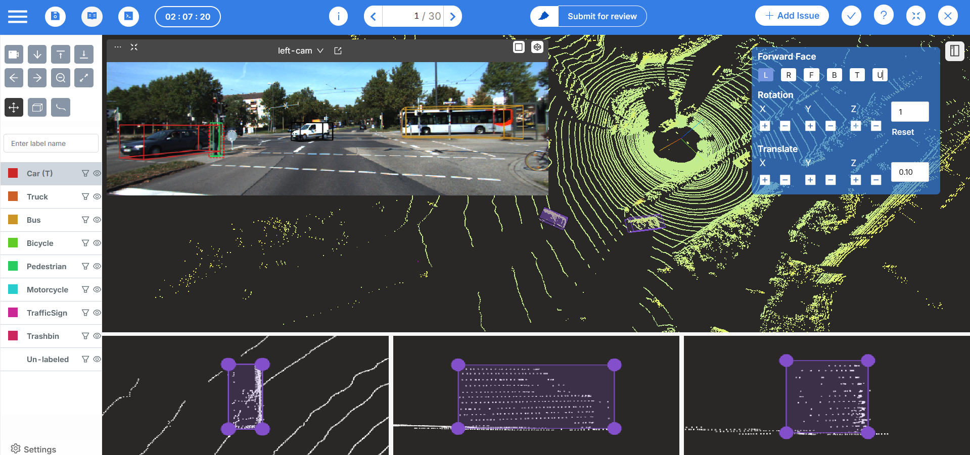
Coral mountain allows you to label point clouds with added context from images. In addition, all annotated cuboids are automatically projected onto the camera images.
Conclusion
LiDAR annotation is central to advancing AI—but it’s also one of its toughest challenges. From sparse data to environmental variability, annotators face a wide range of obstacles. Yet, progress in AI-assisted tools, smart workflows, and experienced labeling teams is steadily closing the gap.
As industries like autonomous driving, robotics, and smart infrastructure scale up, investment in better annotation solutions will be key. LiDAR annotation may be complex, but innovation is making it more manageable every day.
Coral Mountain Data is a company that provides high-quality data annotation services for Artificial Intelligence (AI) and Machine Learning (ML) models, ensuring reliable input datasets. Our annotation solutions include LiDAR point cloud data, enhancing the performance of AI and ML models.