In the fields of 3D modeling and computer graphics, accurately representing physical objects and environments is a fundamental requirement. Point Clouds and Mesh Models are two basic forms of spatial data representation, but they differ significantly in terms of structure and technical characteristics. Understanding the nature, advantages, limitations, and application domains of each method is essential for choosing the appropriate technology and optimizing workflows.
This analysis delves into the technical aspects of both formats, comparing their structures, operational properties, and application potential in the context of modern 3D technologies.
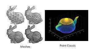
1. Fundamental Data Structure Analysis
A. Point Cloud
A point cloud is a collection of discrete, unstructured data points located in a three-dimensional coordinate system. Each point represents a geometric sample collected directly from the surface of an object or environment.
- Structure: Consists of points (vertices) with (X, Y, Z) coordinates. Each point may also include additional attributes like color (RGB), laser reflectivity, or other metadata.
- Core Characteristic: Lacks topological information. Points exist independently and are not connected in a way that forms a continuous surface. Essentially, it is a raw, detailed recording of spatial shape.
B. Mesh Model
A mesh model is a data structure that represents a 3D surface through a network of interconnected geometric elements.
- Structure: Composed of vertices, edges (connecting vertices), and faces (formed by closed edges, usually triangles or quadrilaterals).
- Core Characteristic: Has a defined topological structure. The relationships between vertices, edges, and faces are explicitly defined, forming a continuous, computable surface. It is an interpretation or approximation of a real surface—not raw data.
2. Technical and Operational Feature Comparison
A. Data Fidelity and Detail
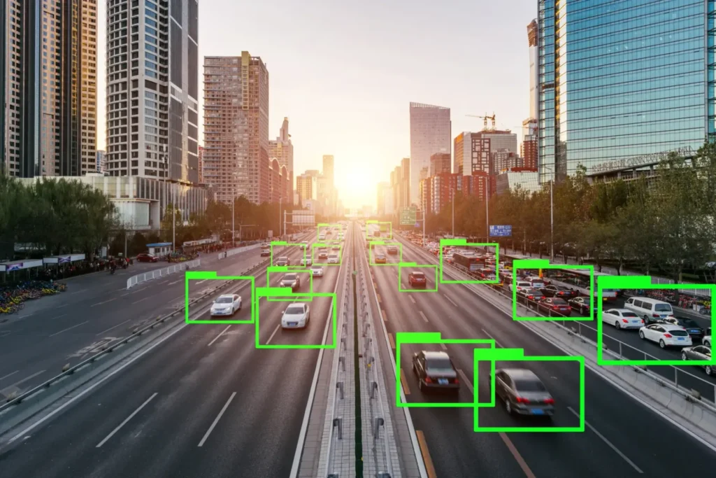
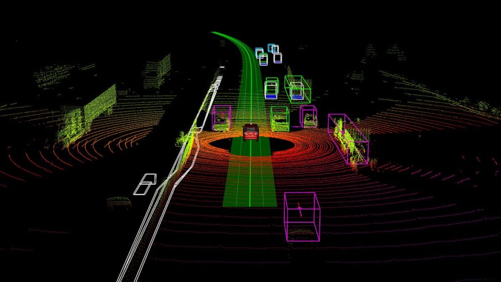
- Point Cloud: Excels in fidelity and spatial detail as it represents raw data collected via technologies like LiDAR or photogrammetry. Ideal for use cases requiring precise measurement, such as structural inspection or reverse engineering.
- Mesh Model: Is an abstraction derived from raw data. The process of converting a point cloud into a mesh (meshing) interprets and often smooths the surface, which can lead to a loss of fine details. The detail level of the mesh depends on its polygon count.
B. Topological Structure and Manipulability
- Point Cloud: Due to lack of topology, operations such as deformation, animation, or direct texturing are complex and inefficient.
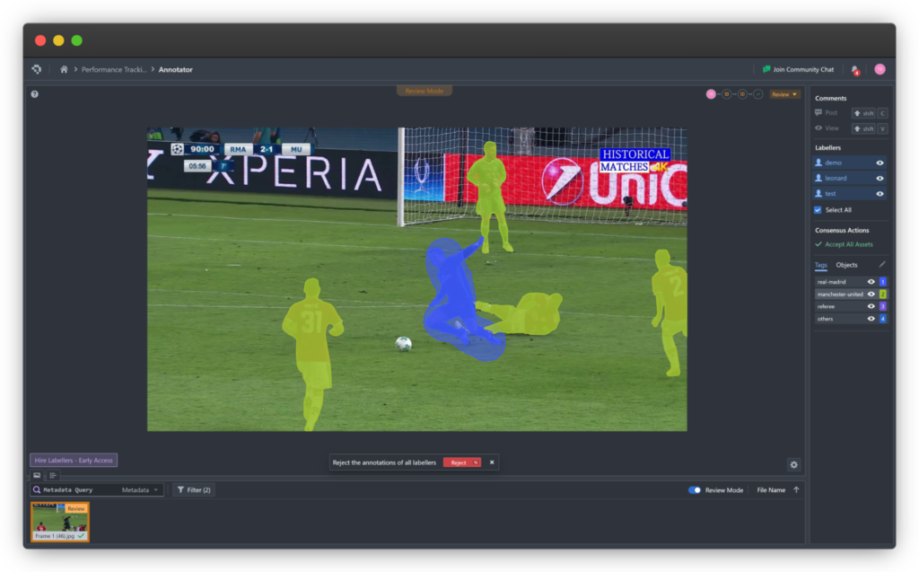
- Mesh Model: Its defined topology allows for easier manipulation. Moving a vertex affects the connected edges and faces, making it the standard format for animation, physical simulation, and CAD design.
C. Storage and Processing Requirements
- Point Cloud: High-resolution point clouds can be extremely large (billions of points), requiring significant processing power and memory.
- Mesh Model: Generally more efficient in storage and rendering, as GPU hardware is optimized for handling polygons. Mesh optimization algorithms also reduce complexity while preserving visual fidelity.
D. Compatibility and Integration
- Point Cloud: Requires specialized software for processing and analysis. Integration into traditional graphics pipelines often requires conversion to mesh format.
- Mesh Model: Widely supported across 3D modeling software, game engines, and CAD applications, making it a standard for many downstream tasks.
3. Application Domains and Conversion Workflows
A. Optimal Use Cases
- Point Cloud:
- Terrain surveying and construction
- Reverse engineering
- Structural and manufacturing quality inspection
- Heritage preservation and forensics
- Mesh Model:
- Game development and film production (characters, environments)
- Virtual and augmented reality (VR/AR)
- Engineering simulation (CAE) and CAD design
- 3D printing
B. Point Cloud to Mesh Conversion
This is a common and critical processing step. It involves complex algorithms that infer surface connectivity from a set of discrete points, converting unstructured data into usable polygonal models for design and visualization applications.
4. Emerging Technology Trends
The 3D modeling field is witnessing rapid advancements impacting both representation methods:
- AI in Point Cloud Processing: Artificial intelligence is automating tasks like semantic segmentation, object recognition, and feature extraction from raw point clouds, accelerating analysis.
- Mesh Model Optimization: New algorithms reduce mesh complexity while preserving important geometric details, enhancing real-time performance.
- High-Quality Real-Time Rendering: Advances in GPUs now enable real-time visualization of massive point clouds and ultra-detailed meshes, blurring the line between fidelity and performance.
5. Conclusion and Selection Criteria
Choosing between point clouds and mesh models isn’t about which is better, but which is more suitable for a specific task.
- Use Point Cloud when:
- Measurement accuracy and data integrity are the top priorities.
- The goal is spatial analysis, inspection, or working directly with scanned data.
- Use Mesh Model when:
- You require operations like editing, deformation, animation, or texturing.
- A continuous surface is needed for visualization, simulation, or production workflows like 3D printing.
Understanding the technical traits and limitations of both formats is essential for any professional working in 3D fields — enabling informed decisions to achieve optimal outcomes in accuracy and efficiency.
Coral Mountain Data is a company that provides high-quality data annotation services for artificial intelligence (AI) and machine learning (ML) models, helping to deliver high-quality input datasets and enhance model performanc