The use of Lidar in archaeology has revolutionized the field, uncovering valuable ancient secrets in the process. Find out how in this blog.
Giới Thiệu
Lidar (Light Detection and Ranging) has reshaped modern archaeology by enabling researchers to reveal structures and landscapes that were once invisible to the naked eye. Using laser pulses to generate detailed 3D maps of the Earth’s surface, archaeologists can now detect ancient ruins and subtle features with remarkable precision.
This technology is especially powerful for identifying buried or obscured sites beneath forests, soil, or modern development, fundamentally changing how we locate, study, and interpret traces of past civilizations.
Lidar scanners
Lidar is a remote sensing technique that measures distance by emitting laser pulses and recording the time it takes for them to bounce off surfaces and return to the sensor. From this, highly accurate 3D models are reconstructed, showing elevation and ground features in fine detail.
Originally developed for meteorology, topography, and other geospatial tasks, Lidar’s ability to map large areas quickly and precisely has made it an invaluable asset for archaeological research.
Processing and analysing Lidar data
The raw output from a Lidar survey consists of billions of measurement points, collectively known as a point cloud. To make this data useful for archaeology, it must be cleaned, filtered, and transformed.
Specialized algorithms are used to remove unwanted returns, such as those from vegetation, buildings, or other “noise”, to isolate the ground surface. Combined with GIS and other geospatial analysis tools, this processing allows archaeologists to interpret subtle variations in terrain that hint at buried walls, mounds, ditches, platforms, or roadways.
Lidar in Archaeology
Lidar is particularly effective in detecting archaeological sites where surface features are faint, eroded, or obscured by vegetation or modern infrastructure. Traditional field surveys can easily miss such traces, but Lidar-derived topographic models reveal fine changes in elevation and shape that correspond to ancient human activity.
From low-relief earthworks to complex urban layouts hidden in forests, Lidar has become a key method for identifying and mapping archaeological landscapes at scale.
Airborne Lidar
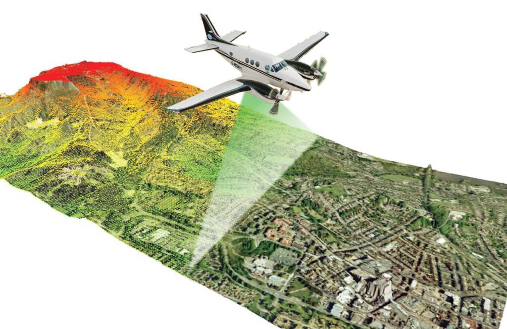
Airborne Lidar is the most widely used form of Lidar in archaeological work. In this approach, a Lidar sensor is mounted on an aircraft or drone that flies systematic paths over the study area.
As it moves, the system emits rapid laser pulses toward the ground. Many of these pulses pass through gaps in vegetation, enabling the sensor to capture returns from the terrain beneath tree canopies or other obstacles. By analyzing the timing and intensity of these returns, researchers generate highly detailed digital elevation models and surface models of archaeological sites-even in dense jungle or remote regions.
Airborne Lidar systems on aircraft or drones emit laser pulses toward the ground. The reflected beams return to the sensor, providing precise distance measurements.
Discover a wealth of knowledge with our curated collection of ebooks and whitepapers. Visit Coral Mountain’s resources page to gain insights and stay ahead in your field.
Advantages of Using Lidar in Archaeology
Lidar offers multiple advantages over conventional archaeological survey methods. Its non-invasive nature and ability to capture highly detailed data across large areas make it a powerful tool for exploring and documenting cultural landscapes.
Penetrates forest canopy
One of Lidar’s most striking strengths is its ability to “see” beneath dense forest canopies. By filtering out returns from tree leaves and branches, archaeologists can isolate ground returns and reveal otherwise concealed features.
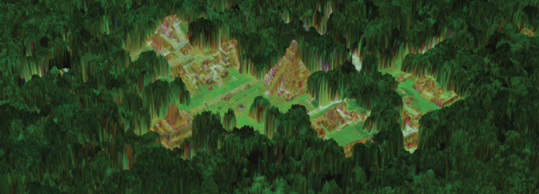
This has been crucial in tropical environments, such as Central America, where entire Maya cities-complete with roads, terraces, and defensive walls-were found hidden under thick jungle.
Produces high resolution data
Lidar provides high-resolution elevation data capable of capturing small variations in terrain. Archaeologists can detect not only major architectural remains like pyramids or large enclosures, but also subtle features such as field boundaries, terraces, embankments, and ancient pathways that might be invisible in traditional aerial photography or ground surveys.
Applications of Lidar in Archaeology
The range of archaeological applications for Lidar is extensive:
- Surveying large and inaccessible areas: Lidar can rapidly cover rugged terrain, forests, and remote regions.
- Discovering lost cities and settlements: Entire urban networks, road systems, and agricultural landscapes have been revealed.
- Mapping infrastructure and land use: Terraces, causeways, canals, and field systems can be analyzed at landscape scale.
- Environmental archaeology: Lidar helps researchers explore how ancient societies modified and interacted with their environment over time.
- Settlement pattern analysis: By mapping sites and features across wide areas, archaeologists can study changes in population, land use, and regional organization through history.
Case Studies
The Maya Civilization in Guatemala
One of the most celebrated examples of Lidar in archaeology comes from Guatemala. In 2018, airborne Lidar surveys covering more than 2,000 square kilometers of Maya lowlands revealed over 60,000 previously unknown features, including temples, defensive earthworks, houses, causeways, and agricultural structures.
These findings dramatically expanded our understanding of Maya urbanism, indicating far higher population densities and more extensive infrastructure than previously assumed.
Stonehenge and its Surroundings
In the United Kingdom, Lidar has been used to explore the wider landscape around Stonehenge. While the stone circle is well known, Lidar surveys have identified numerous additional features, including burial mounds, ancient trackways, and hidden earthworks.
These discoveries show that Stonehenge was part of a much larger ritual and settlement landscape, contributing to a more holistic understanding of prehistoric activity in the region.
Lost City of the Monkey God
In Honduras, airborne Lidar played a central role in locating the so-called “Lost City of the Monkey God,” or La Ciudad Blanca. The region’s dense rainforest had long concealed any traces of large settlements. Lidar maps revealed plazas, earthworks, and substantial architectural remains, providing strong evidence for a once-thriving, previously undocumented city deep in the jungle.
Challenges and Limitations
Despite its transformative impact, Lidar is not a magic solution for all archaeological problems.
- Cost: High-quality Lidar surveys and data processing can be expensive, especially for large regions.
- Data complexity: Interpreting Lidar-derived models requires expertise in both geospatial techniques and archaeology.
- Ambiguity in features: Lidar sometimes struggles to distinguish between natural and artificial forms. Certain landforms can resemble man-made structures, raising the risk of misinterpretation.
- Limited subsurface insight: Lidar maps the ground surface, not deeply buried structures. For features located well below the surface, complementary methods such as geophysical survey or excavation are still required.
Conclusion
Lidar has revolutionized archaeological research by providing an unprecedented view of the Earth’s surface, even under dense vegetation or in hard-to-reach regions. Its ability to produce high-resolution terrain models over extensive areas has led to the discovery of hidden cities, intricate infrastructure, and subtle landscape modifications that were previously unknown.
While challenges remain-particularly in cost, data interpretation, and distinguishing natural from cultural features-the continued development and wider adoption of Lidar promise even more significant discoveries. As technology advances, Lidar will remain a vital tool in uncovering ancient secrets and deepening our understanding of past human civilizations.
Coral Mountain Data is a data annotation and data collection company that provides high-quality data annotation services for Artificial Intelligence (AI) and Machine Learning (ML) models, ensuring reliable input datasets. Our annotation solutions include LiDAR point cloud data, enhancing the performance of AI and ML models. Coral Mountain Data provide high-quality data about coral reefs including sounds of coral reefs, marine life, waves….